A short history of the paddle steamer Iona II
|
Launched: |
25 June 1863 |
Maximum length: |
245 feet (75 m) |
|
|
Sank at Lundy: |
2 January 1864 |
Displacement: |
14,000 tons |
|
|
|
Beam: |
25 ft (7.6 m) |
||
|
Designated a Protected Wreck: |
3 January 1990 |
|
||
|
National Heritage List for England No.: |
10000051 |
Co-ordinates: |
51° 11.03′ N 04° 38.78′ W |
|
The wreck of the paddle steamer Iona II lies approximately 1 km ESE of Tibbets Point, halfway up the east side of Lundy, at a depth of between 22-28 m (depending on the state of the tide).
The following description is taken from Historic England’s National Heritage List website.
“This site consists of the remains of an American-owned paddle steamer which foundered off Lundy in January 1864 in foggy conditions, having left the River Clyde for her first transatlantic voyage via Madeira to Kingston in Jamaica and/or Nassau. There was contemporary speculation that the vessel was purchased in order to act as a gun-runner for the Confederates in the American Civil War. Originally built as a ferry for the Clyde, she was constructed of iron with paddle wheels and a state-of-the-art twin cylinder oscillating engine.”
 Model of the Iona II
 The Iona II in her prime on the Firth of Clyde, a few weeks after her launch in June 1863.
The Iona II was a paddle steamer, launched on 25th June 1863 at Govan by James and George Thompson to ply the Clyde between Glasgow and Ardrishaig and was exceptionally well fitted out. She was built as a fast ferry and had a top speed of 24 knots, being fitted with a novel 2-cylinder oscillating engine fitted with tubular boilers, superheaters and every well-tried improvement. The vessel originally had luxury passenger accommodation, a 75ft dining room and 180ft saloon with velvet sofas.
Given her speed, the Iona II was purchased by Charles Hopkins Boster of Virginia and was engaged to be a Confederate blockade runner; it is believed she was stripped out for this clandestine voyage.
The Iona II was about to forego the relatively calm waters of the Firth of Forth for the stormy seas of the North Atlantic. Her destination was to be Kingston, Jamaica, via the island of Madeira. She was loaded with an undisclosed cargo and a crew of 40. For her intended passage across the Atlantic, strengthening plates were installed along the length of the deck, additional hull frames were fitted and the sides of the vessel were increased in height.
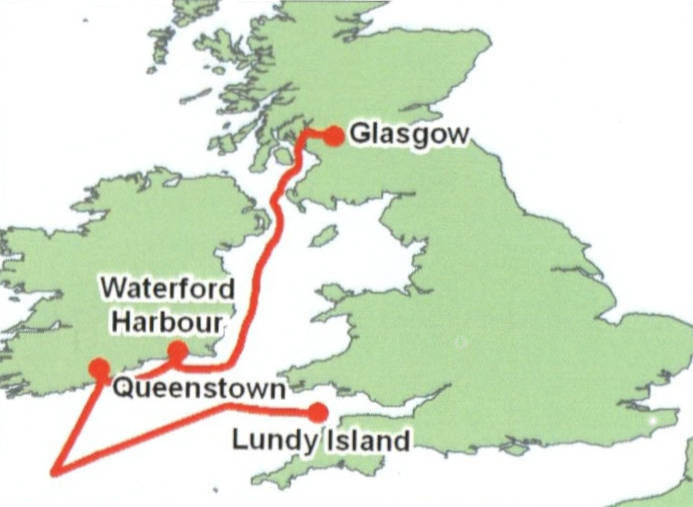
On 16th January 1864, she headed south to Waterford Harbour, in order to drop off the pilot who had accompanied the ship out of the Firth of Clyde and safely along the eastern Irish coast. After six days of waiting out a storm, she then made her way to Queenstown, during which time a small leak was discovered in the hold. This was made good with read lead and oakum while in port. However, thirteen of the stoker firemen were unhappy with the seaworthiness of the ship and refused to continue to work. They were given the option of, “Sail with us or spend ten weeks in jail with hard labour”. They opted to stay put.
After a replacement crew was found and the vessel headed south-west for Madeira. After a couple of days, the hull continued to leak and the bilge pumps clogged. The ship changed course and headed to Milford Haven. By the following day (1st February 1864), there was six feet of water in the hold and the forward boilers had flooded. They changed course again and headed for the shelter offered by Lundy Island. Once there, flares were set off and anchors set. Around midnight on the 2nd February, pilot boats managed to rescue 39 crew and took them to Ilfracombe, there being no loss of life. The vessel sank soon after.
Historic England’s National Heritage List website states: “Further speculation as to her clandestine nature is fuelled by her failure to appear in the list of vessels cleared from ports in the UK to ports in North America during the year 1863 and in the Board of Trade papers at the time. Contemporary accounts describe intensive salvage operations being undertaken soon after the ship sank, with a diving bell being used in her salvage.”
The wreck site today
 The wreck of the Iona II, lying upright on the seabed, with much of the hull hidden by sediment © Peta Knott, Iona II Dive Trail, 2015
It wasn’t until 1976 that the remains of the Iona II were re-discovered off Lundy’s east coast in 22 – 28 m depth of water (depending on the state of the tide). The stern of the wreck lies just 35 m away from the stern of another shipwreck, the MV Robert, a 50 m long coaster which sank in 1975 (though not discovered until 1979). This more recent shipwreck is popular with divers (it still resembles an actual ship, although lying on its side!) and is buoyed during the diving season, making it a good reference point from which to find the Iona II.
The seabed around the Iona II is generally flat, consisting of coarse, firm, level mud and fine silt with some areas of fine sand within the wreck and some gravel patches around the boilers. The levels of sediment around the wreck, particularly of mobile sand, vary from year to year, meaning that on occasion, more parts of the wreck are revealed when the level of sediment drops.
The most noticeable features of the wreck are the two sets of boilers that used to provide the steam pressure to the engine. The smaller pair are in the aft of the vessel and the larger pair are forward. Each pair of boilers shared a smokestack funnel, which was bolted in place. In 1864, soon after the sinking, one section of funnel was salvaged; another still lies on the seabed a short distance from the port aft quarter.
Two of the distinguishing features of the Iona II, which were both major technical improvements in their day and which made the wreck worthy of special protection in 1989, are the paddle wheels and the engine. The paddle wheels were 20 ft in diameter and fitted with patent ‘feathering floats’. These allowed the angle of the blades to be adjusted which increased the wheel’s efficiency. The engine was known as an ‘oscillating engine’, an innovation which also made the engine more efficient in operation, allowing for a piston rod to connect directly with the paddle wheel crankshaft. A considerable amount of debris is present in the vicinity of the centrally-positioned engine and of the remains of the two paddlewheels either side of it.
All the photos below were taken by Mike Deaton on 30th July 2022. Click to enlarge.
 Hull plating
 Forward boilers
 Engine and f'w'd funnel on right
 Starboard paddle wheel
 Engine
 Aft boiler
 Top of aft boiler funnel base
 Forward funnel
 Bow
Bow
In June 2022, as part of the Lundy Marine Festival, a photogrammetry project (funded by Historic England) was undertaken of the Iona II wreck site. Tim Clements (from Vobster Dive Centre) took a series of overlapping photographs of the whole wreck. Wherever there was an object which stuck up from the wreckage, photographs were taken 360° around the object in order to obtain its true 3-D shape. Tim took over 10,000 photographs of the shipwreck which were then processed using specialist computer software to create a 3-D model of the wreck.
The story of the wreck of the Iona II (which includes the 3-D model) is shown in a short 12 min. video which can be seen here.
Monitoring the wreck
As with any shipwreck which remains on the seabed for any length of time, its structure will gradually break apart through the actions of strong tidal currents and of large waves created by storms. We know that a certain amount of salvage work was done on the wreck during the months following its sinking and this could well have led to additional damage. (Quite what it was that the salvage divers were after is not known for sure, but it is suspected it would have been linked to the ship’s expected delivery of a secret cargo to the Confederates on the other side of the Atlantic).
By the time the wreck was discovered some 112 years later, it was really only those parts made of ironwork prominent above the seabed which remained. The hull has been hidden under sediment for much of that time and it could well be that this remains in reasonable condition, protected from the oxygenated seawater which causes rusting of the ironwork and from marine boring organisms which cause the deterioration of woodwork.
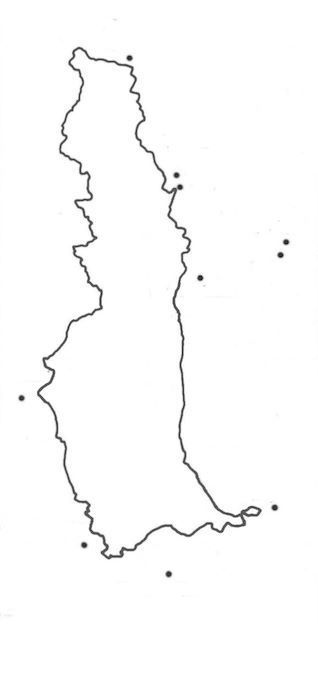
For the past 20 years, the whole wreck site has been photographed from time to time, allowing Historic England to assess the overall condition of the site. To help with this recording process, Historic England are keen for underwater photographers who visit the wreck to take photographs from certain viewpoints dotted around the wreck. These viewpoints are set out in the diagram below. There are 12 viewpoints in all, with the orientation of each being indicated by the camera icons.
Note: an ‘aide memoire’, incorporating the diagram below, is available here for printing out, laminating and then taking under water with you on your dive of the site
 Monitoring viewpoints on the wreck of the PS Iona II © Peta Knott, Iona II Dive Trail, 2015
 Views (in 2014) from viewpoint positions (1)
 Views (in 2014) from viewpoint positions (2)
If you’re interested in diving on the Iona II with a group of similarly interested divers, then take a look at the Protected Wreck Days at Lundy run by the Nautical Archaeological Society. Further information about these Days can be found here.