Fisheries Management
The management of fisheries around Lundy is an important component of the overall management of the MPA. In the days when the voluntary marine nature reserve was set up, the regulating Fisheries Authority was the Devon Sea Fisheries Committee (DSFC). The Marine and Coastal Access Act 2009 saw the disbanding of the DSFC and the introduction throughout England of Inshore Fisheries and Conservation Authorities (IFCAs) as well as another new body, the Marine Management Organisation (MMO). Both agencies are represented on Lundy’s Management Forum, with the D&SIFCA representative attending MPA Advisory Group meetings as well.
Fisheries Agencies’ responsibilities
The Devon and Severn Inshore Fisheries and Conservation Authority (D&SIFCA) is the lead body for activities relating to fishing within the 6 nm limit off the coasts of both south and north Devon and the English side of the Bristol Channel and Severn Estuary. Of the ten IFCAs around the English coastline, the Devon and Severn IFCA has the largest area of sea to manage (4,522 km2).
D&S IFCA’s website should be referred to for the most up to date management measures relating to fishing activity within the D&SIFCA District.
The Marine Management Organisation (MMO) also has jurisdiction within the MPA. The MMO is responsible for marine licensing in English inshore waters (out to the 12 nm limit) and also in offshore waters (between the 12 nm and the 200 nm limits). MMO permission is required for any object to be placed on the seabed (such as the ‘sinker’ attached to a mooring buoy), or for any activity which might disturb the seabed. Whilst many MMO fishery regulations also apply within the 6nm limit, D&SIFCA’s management measures within the 6nm are often more restrictive than national regulations. Beyond the 6 nm limit, the MMO manage fishing fleets, quotas and fighting illegal, unregulated, and unreported fishing.
Fishing activities around Lundy
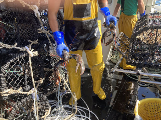
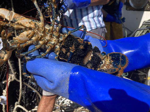
Traditionally, the main commercial fishing interest at Lundy has been for lobster (common lobster Homarus gammarus) and for crab (edible or brown crab Cancer pagurus). These species are caught using baited pots (also known as parlour pots or creels) which are left on the seabed for 24-48 hours before hauling. The pots are usually deployed on ‘strings’ by inshore fishing vessels (mostly under 12 m in length that return to their home ports each night), with each string consisting of 30-40 pots. Each end of the string is marked by a floating buoy. Within the D&S IFCA District, all parlour pots or creels that have a netted entrance and are fishing for crab and lobster must have an escape gap fitted to allow juvenile crab and lobster to escape. Spiny lobsters (also known as crawfish) Palinurus elephas used to be caught with wooden pots and/or nets, but this activity has been banned within D&S IFCA waters for over 10 years now to allow the over-fished stock to recover (see also below).
When compared to most other methods of fishing, potting has been found to have minimal impact on the marine life living on the seabed. For this reason, potting has been allowed to continue within all areas of the MPA apart from within the No Take Zone. However, in recent years, the high price of fuel has deterred all but a handful of boats to come out to the island to set their pots.
Within the D&S IFCA District, as of April 2025, the current minimum landing size for a lobster is 90 mm (carapace length); for a female edible crab it is 150 mm (carapace width); for a male edible crab 160 mm (carapace width); for a spider crab 130 mm (carapace length); and for a velvet swimming crab 65 mm (carapace width). ‘Berried’ lobsters or crabs (that is, holding eggs under the abdomen) must be returned to the sea and are not allowed to be landed. Far fewer spider crab and velvet swimming crab are being caught these days, as the export market to countries such as Spain has dwindled since the UK left the European Union. The current minimum carapace length for landing a spiny lobster caught in neighbouring Cornwall IFCA waters is 110 mm.
When the voluntary marine nature reserve was set up, gill netting was also a typical method used around Lundy (and elsewhere off coasts in the south-west), for catching both open water and bottom-feeding species. Weighted nets were used mostly to catch using spiny lobster Palinurus elephas. The nets would sink to the seabed, typically over rocky ground, and were left for mobile crustaceans to become caught in them. However, when over rocky ground, the nets could also entangle erect sessile species such as pink sea fans and branching sponges. As a consequence, when the statutory Marine Nature Reserve was introduced, the use of gill nets was restricted to a small area close inshore on the east coast, from the Sugar Loaf to Quarry Bay (following a request from some of those living on the island at the time). This area now lies within the No Take Zone, so netting is no longer allowed here either. In addition, the spiny lobster is a featured species of the Marine Conservation Zone and as such it is a protected species at Lundy, its removal being prohibited through regulations introduced by the D&S IFCA. The latest Zoning Scheme (2019, on the right) shows no netting is permitted inside the blue area (#2) within the MPA.
Demersal trawls (that is nets which are towed over or just above the seabed) are allowed to operate in the north-east corner of the MPA (as indicated by the orange-coloured area on the Zoning Scheme); and dredges are allowed to operate in the very north-east part of the MPA (indicated by the green area). These areas of the MPA have a bottom type of sand which, because of its mobile nature, has very few species associated with it as a habitat type. This is why these fishing practices, which are designed to catch mid-water and bottom-dwelling species, are allowed to continue. Each year, a review of these areas is carried out by D&SIFCA to assess how frequently boats using mobile gears have entered these areas. A low level of bottom trawling for squid only takes place during a couple of months over the summer period.
Recreational angling from the shore or from boats is permitted in all areas except for within the No Take Zone. Targeted fish from spring to autumn can include mackerel, herring, bass, whiting, conger eel, plaice, bull huss/nursehound and thornback ray. Cod and flounder tend to be caught more during the winter months.
The D&S IFCA was the first IFCA to introduce a new system of managing their sea area through the introduction of permitting byelaws. For the whole of the District (including the Lundy MPA), permits are required to conduct mobile fishing, potting, netting and diving for scallop, crab and lobster. Permits are needed to conduct these activities both commercially and recreationally.
Reporting suspected fisheries infringements
The Warden plays a key role in overseeing the day-to-day running of the MPA (see also Day-to-day management). Keeping an eye on fishing activity is a major part of this, as the island is too far offshore for regular visits by D&S IFCA Officers. To aid D&S IFCA’s monitoring of compliance with fishing regulations around Lundy, the Warden can provide information on suspected illegal activity to D&S IFCA and speaks directly to IFCA colleagues should the need arise.
The reporting of suspected illegal activity by the Warden has become increasingly important following the establishment of the No Take Zone in January 2003. The Lundy No Take Zone was introduced by DSFC formerly under a byelaw in 2003 and is now regulated by D&S IFCA and is managed through D&S IFCA’s permitting byelaws.
Since its creation, there have been a number of incidents relating to fishing activity within the NTZ which have required investigation, some more serious than others. On occasion, staying visitors may be seen angling off rocky promontories such as Brazen Ward along the east coast, which is within the NTZ. On such occasions, the culprit concerned will have their attention drawn to the MPA’s Code of Conduct and be asked not to fish within the No Take Zone again. More intentional disregard for the No Take Zone’s byelaws has also happened, when a pot fisherman deliberately began setting his string of pots outside the NTZ, then continued to set the others in a loop within the NTZ, ending with the last pot being outside the boundary again. This time the infringement was reported to D&SIFCA who took the appropriate enforcement action. The most recent, serious offence took place in July 2023 when a Belgian trawler took shelter off the east side of the island. The vessel had entered the MPA with its net gear in the water over the side. Being under way, it could have been actively fishing, although the skipper later explained his crew were washing the net, that it was well clear of the seabed and that it was not fishing at all. Gear-streaming, as it is known, is an offence under D&S IFCA Mobile Fishing Permit Byelaw which states that “all gear should be lashed down or stowed when a vessel is within areas closed to mobile fishing vessels within a Marine Protected Area”. D&S IFCA Enforcement Officers investigated the offence, and an advisory letter was sent to the owner of the vessel.
It is not always possible for a member of Lundy’s Conservation Team to witness such incidents at first hand and they rely to a great extent on visitors to the island to report any suspicious activity to the Team. In the incident described above, it was reassuring to know however that not only did members of the Conservation Team spot this activity at the time, but that several members of the public reported it to the Warden as well. D&S IFCA, under its Mobile Fishing Permit Byelaw Conditions, requires all trawlers and scallopers to have a functioning Inshore Vessel Monitoring System (IVMS) on board which allows IFCA Officers to remotely monitor fishing activity and gather evidence should an infringement take place.
Any suspicious fishing activity can be reported directly to D&S IFCA via a form on the website or by phoning the incident line on 07740 175479.
Remote monitoring
Between April and June 2022, OceanMind (a not-for-profit company specialising in satellite and other forms of remote sensing in the marine environment) undertook an experimental survey monitoring the movement of vessels in and around five UK MCZs off the English coast. Lundy was chosen as one of these five sites.
The project used remote sensing (Synthetic Aperture Radar & Electro Optical) and vessel tracking (Vessel Monitoring System (VMS) for vessels over 12 m in length; Inshore Vessel Monitoring System (IVMS) for vessels under 12 m) to monitor activities within these MCZs.
An example of how vessel movements can be detected is shown in the illustration below. Using an Electro Optical image (taken from a satellite), two charter boats are detected off the east side of Lundy within the MCZ, one under way and the other moored to a buoy. A photograph taken from the island provides colour and an opportunity to identify the vessels in question. Should the actions of either of these vessels have been suspicious (which it wasn’t!), then it would have been possible to identify the vessel and to question the skipper after the boat had returned to port.
Machine learning (also known as Artificial Intelligence or AI) is also being used in conjunction with these detection systems, allowing data to be filtered in such a way so that only potential non-compliant activities need to be analysed in detail. Unmanned Aerial Systems (more commonly known as drones) may also be used to complement satellite remote sensing methods, providing a greater amount of photographic or videographic detail.
The resulting Intelligence Report from OceanMind at the end of the project (July 2022) highlighted the following:
- A vast array of different vessels visit the site frequently during the early summer months, often without broadcasting on AIS;
- Historic AIS analysis revealed that this is a location where larger vessels shelter during periods of poor weather;
- Remotely taken images (covering 25% of days during the monitoring period) suggest that the area has a high level of compliance with fisheries regulations, there being no high-risk detections within the monitoring period;
- A limitation of remote sensing is that catches by fishing vessels cannot be checked using remote sensing methods and therefore compliance with no-take regulations cannot be verified;
- The Lundy MPA is an example of effective marine protection.
![Black & white satellite images taken of two vessels within the Lundy MPA, with their identities confirmed by the colour (background) photograph, taken some three hours later from the island [2022 Maxar Technologies Ltd. & 2022 OceanMind Ltd.]](/images/basic-pages/history and management/2.2.5M_Image2 from OceanMind presentation_Greg Brown_Sep22_Screenshot_29Apr25.jpg) Black & white satellite images taken of two vessels within the Lundy MPA, with their identities confirmed by the colour (background) photograph, taken some three hours later from the island [2022 Maxar Technologies Ltd. & 2022 OceanMind Ltd.]
Black & white satellite images taken of two vessels within the Lundy MPA, with their identities confirmed by the colour (background) photograph, taken some three hours later from the island [2022 Maxar Technologies Ltd. & 2022 OceanMind Ltd.]