An inquisitive grey seal © Keith Hiscock
  Encrusting sponges with a spiny starfish, Knoll Pins © Paul Naylor@marinephoto
  Expanded and contracted colonies of Red sea fingers Alcyonium glomeratum, Knoll Pins © Paul Naylor@marinephoto
In order to check how well (or poorly) the Marine Protected Area is faring, regular checks are undertaken to assess its ‘condition’ (particularly the habitat and species features identified by Natural England when the SAC and the MCZ were established) and how the MPA is being managed. Natural England have produced a booklet which explains how they set about assessing the condition of features within MPAs, which can be downloaded here.
The initiation of long-term monitoring projects began in the mid-1980s, when certain sessile invertebrate species of high nature conservation interest were studied over a number of years, particularly to see how long an individual’s lifespan was likely to be. This is considered in more detail here.
Providing an assessment of the condition of the MPA began when the statutory Marine Nature Reserve became a Special Area of Conservation, being an obligatory requirement of SAC status recognition. The condition of each named feature of the SAC (which in Lundy’s case were: intertidal and subtidal reefs; subtidal sandbanks; submerged or partially submerged sea caves; and grey seal) required reporting on, via English Nature (or Natural England after October 2006). Assessments for all SACs were collated with submissions from the other country agencies by the Joint Nature Conservation Committee, and then submitted to the Directorate of the Environment in Brussels, at least once every six years.
A division of labour for these monitoring tasks for the Lundy SAC was gradually introduced between Natural England and the island authorities. The Lundy Warden and his/her assistants would lead on the monitoring of intertidal reefs; and they would also undertake regular surveys of the grey seal population, including the counting of pups during pupping season. Sea caves were ‘put on the back burner’ as, whilst Lundy has very few subtidal caves, those in the intertidal (over which there are at least 60) have a restricted biodiversity, especially when compared to intertidal chalk caves elsewhere in England. Subtidal sandbanks would require the services of contractors experienced in sediment infauna; and subtidal reefs would require the services of diving marine biological contractors, as English Nature at the time did not have an in-house diving team.
The first such subtidal reefs condition assessment was undertaken in 2003/04 (see Mercer et al., 2006 in the Bibliography). The team of marine biologists were tasked with establishing the methodology for monitoring the condition of the SAC’s subtidal rock sub-features and then undertaking the first monitoring events. The initial results provided baselines upon which future monitoring studies could be compared. Over the years, the agreed ‘attributes’ associated with each sub-feature would indicate if the sub-feature was in favourable or unfavourable condition, as set out in the table below:
Table: Identified sub-features of the subtidal reefs feature for condition monitoring.
|
Feature |
Sub-feature |
Attribute |
Methods |
|---|---|---|---|
|
Kelp forest communities & subtidal bedrock and stable boulder communities |
Kelp forest communities & subtidal bedrock and stable boulder communities and Eunicella-characterised reef |
No decrease in distribution, extent and range of biotopes from baseline |
Drop-down video |
|
Kelp forest communities |
Kelp forest communities |
Algal species composition: no significant deviation from baseline |
Diver survey of biotope, targeting algal species composition |
|
Subtidal bedrock and stable boulder communities |
MCR.ErSPbolSH biotope |
Species composition: no significant deviation from baseline |
Diver survey of biotope, targeting species composition |
|
Subtidal bedrock and stable boulder communities |
MCR.ErSEun biotope |
Species composition: no significant deviation from baseline |
Diver survey of biotope, targeting species composition |
|
Subtidal bedrock and stable boulder communities |
FaV; ScAs.ByH biotope |
Species composition: no significant deviation from baseline |
Diver survey of biotope, targeting species composition |
|
Subtidal bedrock and stable boulder communities |
MCR.ErSEun biotope |
Average density of sea fans, proportion of damaged or epiphytised branches: no significant deviation from baseline |
Random drop-down videa ‘drops’ within biotope |
Subsequent subtidal reef condition assessments have taken place in 2010 (see Irving, 2011), in 2014/15 (see Vance & Ellis, 2016) and a much reduced assessment by an in-house Natural England team in 2022 (which unfortunately experienced poor weather which led to the cancellation of most of the assessments).
 Potato crisps bryozoan Pentapora foliacea with a spiny starfish Marthasterias glacialis, off the Battery © Paul Naylor@marinephoto
  Spider crab sponge decoration © Paul Naylor@marinephoto
  Fried egg nudibranchs Diaphodoris luteocincta on bryozoans © Paul Naylor@marinephoto
Favourable or unfavourable condition status?
As pointed out in the section above, the current condition status monitoring regime assesses the named features and sub-features of the Special Area of Conservation (SAC) determining whether their condition is favourable, unchanged/stable or unfavourable. The same parameters are used to provide an assessment of the condition of the Marine Conservation Zone, with the addition of the sole named feature for the MCZ, the spiny lobster Palinurus elephas. By and large, these assessments, which are reported on every six years, have indicated that the condition of almost all sub-features have remained in favourable condition. However, indications of the condition of individual species or certain communities, might suggest all is not ‘so rosey’ within the MPA.
One of the findings of the first sublittoral monitoring programme undertaken between 1983-1987 was that “Overall trends in the abundance of southern species at Lundy are downwards” (Hiscock, 1994). In a later paper, Hiscock (2002) mentions that “analysis of viewpoint photographs of the Knoll Pins monitoring site taken in 1996 and a general difficulty in finding certain species to photograph which were widespread in the early 1970s led to the conclusion that the marine life was not as rich as it had been in the period to the mid 1980s.” In this same paper (Hiscock, 2002), the author goes on to list personal observations of 28 species whose presence or abundance has changed in some way between the early 1970s and 2001.
One might assume that these signs of change are likely due to human impacts. For instance, could the dumping of sewage sludge at designated disposal sites off the south Wales coastline and also 11 miles off Ilfracombe have had an impact? The practice ceased in October 1992. Or possibly the extraction of gravel from the Bristol Channel causing increases in the suspended sediment load? Or possibly the use of tributyl-tin in antifouling paints used on ships’ hulls? Nutrient levels in the Bristol Channel were observed to have been elevated during the late 1990s (Environment Agency, 1999), possibly leading to increased growth of macroalgae and even sessile animal species such as erect bryozoans. However, it could also be pulses of warmer seawater which can affect south-west England from time to time; or even the entirely natural alteration of movements of water around the British Isles rather than to increases in temperature.
Determining what might be responsible for the downturn in the overall condition of seabed communities is no easy task. However, the more monitoring that can be done of both the communities afflicted and of the possible causes of their affliction, the better.
See also descriptions of the demise and slow recovery of pink sea fans here and the declining numbers of sunset cup corals here.
 A report on the management of MPAs by the French Global Environment Facility (FGEF) featured the Compass Card idea which was utilised by WWF UK.
MPA Management Assessments
WWF-UK Compass Assessment of MPA Management
In 2017/18, WWF’s UKSEAS project aimed to find out (on a national basis following the designation of three tranches of MCZs from 2013 to 2018), how many of these were being ‘well managed’. Various schemes for undertaking such a task had been tried elsewhere in Europe, but one stood out which provided a helpful visual summary pertinent to the site in question. This was a French one which introduced theconcept of a ‘Compass Card’ to indicate which functions of an MPA were being undertaken well and which poorly.
The resulting diagram (the ‘compass’) combines a pie-chart (with coloured segments indicating the various stages in the development of an MPA) with 37 different, specified ‘stages’ or ‘processes’ which an MPA might be expected to undergo during its development, as overseen by its managers.
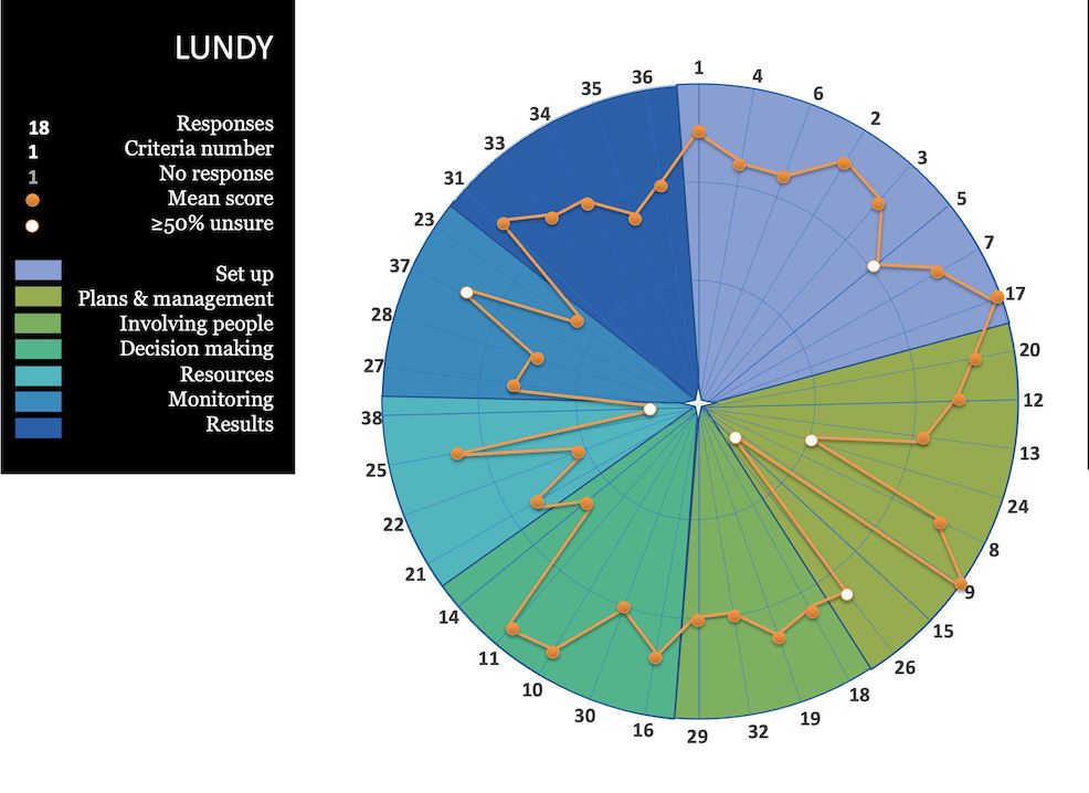 The resulting MPA Compass Card for Lundy, October 2018. © WWF-UK
Each ‘process’ is awarded a score (between 0 and 3) indicating how poorly or well that process is rated by people who have been asked (via an on-line questionnaire) to give their opinion. These people were a cross-section of those who had a connection of some sort with the MPA – such as users of the MPA, MPA Advisory Group members or members of the public. The mean of their scores for each process were then plotted on the compass card (the orange dots shown on the graphic).
We’ve picked out some of the ‘highs’ and ‘lows’ for the Lundy MPA. The high scores include: #17 [Q: Does the protected area have legal status?]; #9 [Q: Does the protected area have management in place for each zone as appropriate to meet the site's objectives as a whole?]; #10 [Q: Does a management body exist that is empowered to set the MPA’s strategy, objectives and overall direction?]; and #11 [Q: Does a management committee exist that implements the strategy?].
The low scores include: #24 [Q: Does the MPA have a business plan describing how income can be generated to deliver the MPA objectives in the long term?]; #15 [Q: Have alternative income generating activities been considered to compensate for displacement of damaging activities in the MPA?]; #38 [Q: Is there long term funding for the full cost of the MPA and its management/operating costs?]; #22 [Q: Is the infrastructure and equipment needed to manage the site available?]; and #23 [Q: Is enforcement of management rules undertaken?].
The white dots on the graphic indicate that 50% or more of replies to the posed question were “unsure”. These markings must therefore be afforded some leeway. It also indicates that those involved with the MPA’s management need to be more explicit with their messaging about how the MPA is run.
The number of respondents to the 2018 questionnaire for the Lundy MPA was just 18. It will be interesting to see, if the exercise was to be repeated at some time in the future, whether that number could be increased and whether the positioning of the mean response scores could be pushed nearer to the perimeter of the chart, thus indicating a better understanding of how the Lundy MPA is being managed.
 The range of responses to a sample question asked in the Lundy MPA questionnaire. © WWF-UK

Recent MSc study into the governance of the Lundy MPA
In December 2023, a research dissertation was submitted for the MSc degree in Environment, Politics and Society at University College London by Theodora Stephens-Manassieva (Supervisor: Dr Peter Jones) entitled: Shipshape and Bristol fashion: an MPA success story in the channel. Governance analysis of Lundy Island MPA, United Kingdom.
The following passage is taken from the Abstract included at the beginning of the Theodora’s dissertation.
“Over-extraction, habitat destruction, biodiversity loss, pollution and climate change all threaten the health of the ocean. In response to these threats, there has been growing recognition of the need and value of Marine Protected Areas (MPAs). How MPAs are governed and through what mechanisms remains an important question to determine the efficacy of protection. The aim of this research was to explore the governance effectiveness of Lundy Island MPA. Lundy Island holds a venerated status, established over 50 years ago and protected by several important designations. Qualitative data were gathered from a wide variety of constituents using semi-structured interviews, ethnographic participation and observation, underpinned by discourse analysis. The Marine Protected Area Governance (MPAG) framework was then applied to assess how effectively the MPA is being managed. The research revealed that Lundy is managed through a top-down, government-led approach, but one that is greatly reliant on local leadership, in particular. Statutory bodies and government agencies have played a central role in Lundy’s management, which has been supplemented with partnerships with other key actors, such as fishermen, scientific researchers, and business operators.
Given its location, Lundy is considered as ‘low risk’ by relevant authorities - it is assumed that Lundy experiences fewer pressures and therefore is less vulnerable or sensitive than other MCZs. As one interviewee put it, it ‘is simply ticking over’ [20]. Acute lack of funding is a huge challenge, which impacts a number of areas, including monitoring, implementation of the Marine Management Strategy, and enforcement. Funding should also be used to address these areas, and commit to long-term monitoring plans that would add to an already bountiful archive; it would inform others as to what a protected marine environment could - and should - be like, compared to other MPAs around the country. Thinking about its history as ‘the first’ of everything, the next challenge for Lundy’s managers and users will be to define what it could be the first at next.”