Lundy’s location on the fringe of the Celtic Sea, together with the minimal amount of run-off from the land into the sea, leads to the island being bathed in relatively unpolluted water which can, on occasion, display excellent visibility (over 12 m), particularly after a period of calm weather (plankton blooms excepted). However, the position and orientation of the island in the Outer Bristol Channel means it can be subjected to very strong tidal currents, so it is essential that you understand the tidal streams which can occur at each dive site.
As a result of the potentially hazardous conditions, diving around Lundy should not be attempted by novice or inexperienced divers. For groups of divers, it is advisable to use one of the experienced dive charter boats, as their skippers have excellent knowledge of the dive sites making the whole experience safer and more enjoyable. Given the variable wind, sea and tidal conditions on any particular day, they will be able to recommend where and when to dive certain sites. Shore diving is limited to only a couple of safe entry points from the shore.
The Lundy Warden oversees the management of the Marine Conservation Zone, the Special Area of Conservation and the No Take Zone (all part of the MPA). This includes the day-to-day running of the dive facilities, at the back of the Beach Building close to the jetty. The Warden would be happy to advise you on any aspect of diving on Lundy. Please feel free to contact the Warden before your visit by emailing
There are numerous dive sites around the island, all offering something different for the adventurous diver. Those interested in shipwrecks have a selection to choose from, some of which are described in further detail here. The descriptions of a selection of ten dive sites are provided below. The site descriptions (with suggested routes to follow when under water) can be printed off and laminated, allowing them to be taken under water on your dive. They have been prepared with help from members of the local Appledore Sub-Aqua Club.
The location of a selection of dives sites, together with an indication of seabed types around the island, is provided in the illustration below.
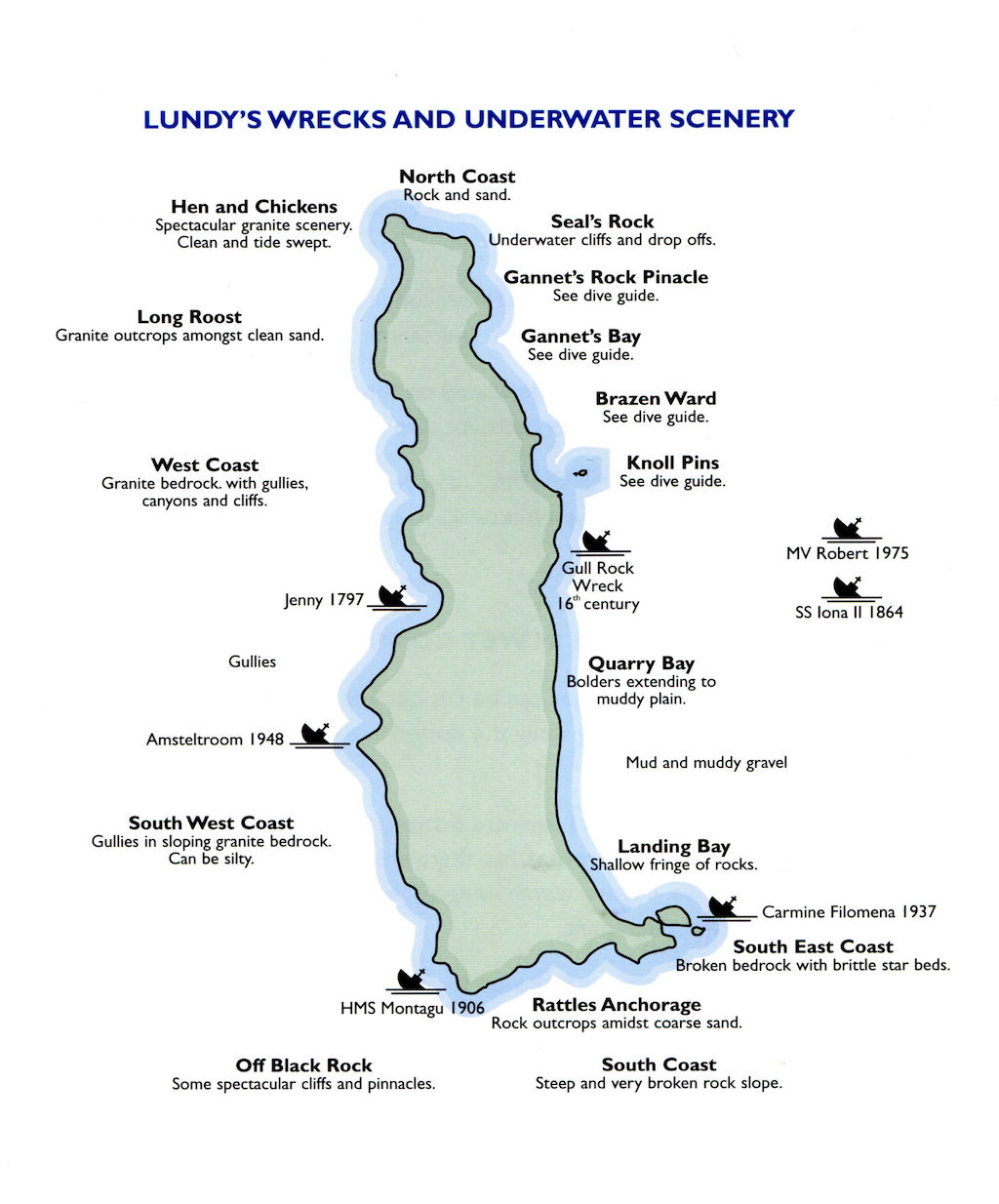 A selection of dive sites and indications of seabed types around Lundy (taken from Paul Kay’s The Scuba Diver’s Guide to Lundy Marine Nature Reserve, published by English Nature in 2001 and now out of print).
For more information on diving from Lundy, that is if you’re thinking of staying on the island, please follow the link to the Landmark Trust/Lundy website, where you can find information about the facilities, services offered and prices.


